
Watch here: Nature's Sure Connected End of Project Conference
Evidencing Landscape-Scale Conservation
Nature's Sure Connected is an exciting biodiversity monitoring project working in partnership to evidence landscape-scale conservation and secure a wilder future.
We want to figure out how the conservation community can work together and share data to better monitor the state of nature - and the impact of our conservation actions - at a landscape scale. The project will enable us to produce a tested landscape-scale monitoring framework to help us understand the state of nature in the wider landscape.
This project is being led by Kent Wildlife Trust and has been funded by the National Lottery Heritage Fund.
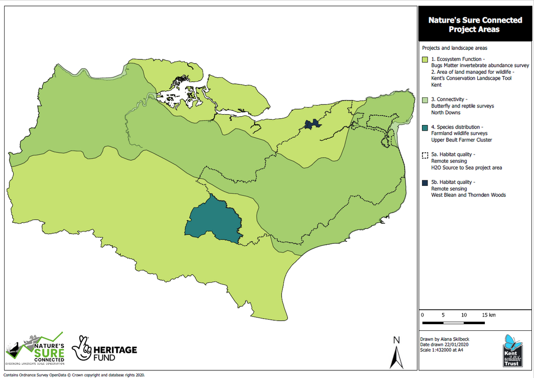
Where is the project taking place?
Why did we embark on this project?
Lots of organisations undertake practical conservation work and collect ecological data, but few of us have the time or resources to collect all the data we need, nor to look at the big picture to see what impact our actions are having on biodiversity across landscapes. Nature’s Sure Connected will help conservation organisations to make a huge leap forward in evidencing landscape-scale outcomes of landscape-scale conservation actions.
How are we helping as an organisation?
The project will produce a landscape-scale monitoring framework that can be applied to any landscape-scale conservation scheme, embedded in Kent's conservation community and shared nationally. It will develop approaches to answering 5 key landscape-scale questions that were prioritised by 100 stakeholders (conservation practitioners from across the conservation sector) during our consultation process.
The five key areas we are focusing on:
How can we measure the area of land managed for wildlife at a landscape scale?
In order to develop an approach to answering this question, we investigated other organisations approaches through an online consultation. These responses were then consolidated and reviewed and informed the development of our approach. The findings from this research have fed into our development of a web-based tool that will enable organisations to contribute their data to a landscape-scale evaluation of the area of land managed positively for wildlife.
How can we measure habitat quality at a landscape scale?
After considering both field survey and remote sensing options, we settled on developing our knowledge and capacity to conduct UAV-based remote sensing. Our consultation told us that others have trialled field survey approaches to quantifying habitat at landscape-scale, so rather than re-invent the wheel; we are focusing on the cost-to-scale effective possibilities offered by remote sensing.
The project has allowed us to begin evaluating equipment, budget, training, legislative and practical considerations for remote sensing and we will share our learning and experience at the end of the project. An exciting element we are investigating is the use of 'Digital Surface Models' to evaluate structural elements of habitat quality at landscape scales.
How can we measure connectivity at a landscape scale?
Connectivity modelling tools are a popular and useful approach to answering this question. However, they are only able to produce theoretical results.
A connectivity modelling tool is a computer software package that can look at existing habitat in a landscape and plan a route between these areas of habitat that are permeable to a particular species. Expand on this. Like a route planner, it establishes how plant and animal species could theoretically move from one patch to another based on the quality and ease of movement between areas. Many tools can also be adjusted to the dispersal rate of a particular species. For example, adders might move up to 2km in a year between suitable reptile habitats, and tools can reflect this.
Based on changes in the landscape, we can model whether it is theoretically more or less connected or a given species. Stakeholders told us they want to be able to validate these models with field data to demonstrate functional connectivity – real data of species actually moving through the landscape - so are developing a dual approach:
- Modelling tools: there are is a bewildering array of tools out there. We are conducting a comparative analysis of these tools, and testing their use. We’ll be sharing our assessment and experience with our stakeholders at the end of the project.
- Field survey: To validate the model outputs, we developed and trialled a field survey approach this summer. Our species selection was informed by the criteria for selecting landscape-scale indicators that was developed through a series of workshops. Surveys were conducted to look for Adonis blue and silver-spotted skipper butterflies as well as Adder across the landscape area of the North Downs, Kent.
We have secured multiple partnerships with recording groups to establish a sustainable, high quality and cost-effective data collection monitoring system across Kent.
In order to work at a landscape-scale, you need to work collaboratively. Nature Sure Connected is doing just that by creating 5 new partnerships with other conservation organisations. We have created partnerships with Butterfly Conservation and Kent Reptile and Amphibian Group whilst looking at functional connectivity at a landscape scale.
How can we measure species distribution at a landscape-scale?
Our stakeholders prioritised developing a practical approach to monitoring population size at landscape-scale. Establishing the numbers of individuals of a species in a population is typically very resource and labour intensive, meaning it is frequently unachievable at landscape-scales. Our approach uses the principle that species distribution can act as a proxy for abundance. When populations grow or contract, the area they occupy also grows or contracts. By measuring the area occupied by a population, we can detect changes in its size, without needing to count every individual.
During consultation, stakeholders highlighted the need for monitoring to address the 70% land area of the UK that is farmed. In 2019 Kent Wildlife Trust recognised a growth of the farmer cluster method and Nature’s Sure Connected saw this as an opportunity to develop an approach to landscape-scale monitoring in this context. We are currently working with KWT’s Farmer Cluster Officers to develop conducting wildlife surveys on the clusters member’s farms.
This has created a new volunteering role in which we ask volunteers to help farmer’s survey wildlife on their farms. If this is something you would like to get involved with please follow the link to the role or contact one of the members of the project team.
How can we measure ecosystem functionality at a landscape scale?
What is Ecosystem functionality? It is a technical term used to define the biological, geochemical and physical processes and components that take place or occur within an ecosystem.
This term covers a wealth of functions that species, habitats and processes deliver (pollination, clean water and air, pest control, decomposition, carbon storage, food provision… the list goes on). Looking at all these areas is beyond the scope of the project, consequently, we settled on addressing one function with immediate and topical relevance: insect declines and the implication for food webs.
To answer this question we have successfully trialled a survey last conducted by the RSPB in 2004, and not repeated since. The Bugs Matter survey offers a novel way to engage large numbers of citizen scientists in collecting vital data at a huge scale. It works simply by counting the number of insects squashed on car number plates using a simple grid. Between June and September 2019 volunteers completed 663 journeys from various locations across Kent.
Key Findings: Insect Decline is Real
Between 2004 and 2019 there was a statistically significant decline in ‘splat density’ of the order of approximately 50%, from an average of 0.2 splats per mile to 0.1 splats per mile.
The Windscreen Phenomenon is Real
The windscreen phenomenon is a term given to the anecdotal observation that people tend to find fewer insects squashed on the windscreens of their cars now, compared to a decade or several decades ago. This effect has been ascribed to major global declines in insect abundance. Modern cars are more aerodynamically designed, however, and it has been speculated that they may cause more insects to pass over vehicles smoothly, without getting squashed. If true, perhaps the apparent decline in splatted insects is an artifact of design. To address this we recruited classic car owners to take part in the survey, allowing us to collect data using cars ranging in age from 1957 to 2018. Contrary to the anticipated effect of vehicle age, we found a small but statistically significant positive relationship between vehicle age and splat density, suggesting that modern cars squash more invertebrates than older cars.
If this is something you would like to get involved with please follow the link to Bugs Matter Survey for spring/summer 2021 or contact one of the members of the project team.
Conservation Evidence Champions
Through the project, Kent Wildlife Trust has achieved accreditation as a Conservation Evidence Champion.
Kent Wildlife Trust is the first Wildlife Trust, and first organisation in Kent to achieve accredited status as an Evidence Champion, working closely with the Cambridge University-based organisation Conservation Evidence. Find out more about Conservation Evidence and our Evidence Champion status here.
"Kent Wildlife Trust is a leader in the use of evidence in conservation practice"Bill Sutherland, Miriam Rothschild Chair in Conservation BiologyConservation Science Group, Department of Zoology, University of Cambridge